Case study Peru
Undergraduate students (MSc level), graduate students, early career professionals
Learning objectives
- Be familiar with the concept of joint knowledge production in climate change adaptation
- Increase knowledge on the environmental and social context of the Negro river catchment and the factors that influence risks and risk perceptions
- Appreciate the extent that different perspectives from natural sciences and social sciences are relevant in the design and appraisal of climate change adaptation measures
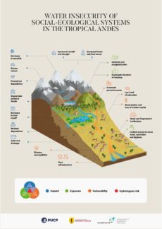
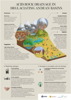
Climate change in the Peruvian Andes is generating a wide range of impacts for human and natural systems in the mountains and downstream areas. Glacier retreat has several implications for water availability including changes in seasonality and a reduction in dry-season river flows. In addition, some catchments in the Peruvian Andes experience a strong deterioration in water quality due to a natural process commonly known as acid rock drainage. This phenomenon is linked to glacier retreat and the consequent exposure, weathering and mineral leaching of eroded rocks and fine sediments that can lead to considerable water acidification.
The headwaters in the Cordillera Blanca in Peru, the mountain range with the largest extent of tropical glaciers worldwide, are dominated by sulphide- and pyrite-rich rocks of the Chicama formation that can contribute substantially to acid rock drainage processes and water deterioration. In this context, Andean communities located in deglaciating catchments are facing an aggravated situation with increasing uncertainty about adequate water quantity and quality for their livelihoods in the medium and long term. They depend largely on local water for agriculture, livestock and daily consumption and are often highly vulnerable and exposed to deteriorating water quality due to acid rock drainage. Increasingly acidic water becomes toxic and has severely detrimental effects on the human health of these communities, their livestock and other living organisms in the surrounding Andean ecosystems.
This case study introduces the Negro river catchment in the Cordillera Blanca, Peru. It presents the hydrological risks arising from glacier melt and how local communities respond to water quality deterioration taking into consideration multi-stakeholder and multi-level water governance systems. This integrated understanding enables an assessment of water security in the Rio Negro basin, in other basins in the Peruvian Andes and beyond.
Questions
1) What are the risks that the communities of Canrey Chico and Cordillera Blanca in Peru are or will be facing?
2) How can the communities respond to these risks?
3) Which responses do you consider to be most appropriate?
Perspective 1 – Natural Sciences
Lecturers Fabian Drenkhan and Martín Leyva
Learning objectives
- Identify the main risks to mountain water security in the Andes of Peru and in the Negro river catchment
- Develop strategies of adaptation interventions to counteract deteriorating water quality in deglaciating catchments
Perspective 2 – Social Sciences
Lecturer Sofia Castro
In this perspective, students will gain an insight into the risk perceptions of the local population of the community of Cordillera Blanca and its importance for adaptation to climate change. Therefore, joint knowledge production, i.e. the integration of diverse knowledge (e.g. local, indigenous, scientific) into a common baseline to better understand and deal with risks, will be a key issue. The perspective follows an anthropological approach, using theoretical concepts and methodologies of the qualitative social sciences.
Learning objectives
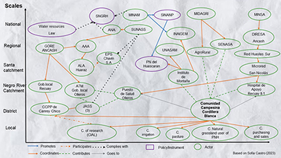
- Understand risk perceptions and local governance systems of the community of Cordillera Blanca
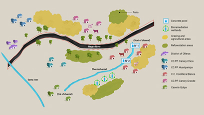
- Get familiarized with the concept of joint knowledge production with an emphasis on diverse knowledge (e.g. local, indigenous, scientific) using participatory cartographies
- Identify suitable ways to respond to deteriorating water quality considering risk perceptions, local governance systems, diverse knowledge and integrated approaches and interconnections to jointly design, plan and implement local adaptation strategies
Lecturers reflect on the work produced, the methods employed, the learning experiences, the challenges, etc. in relation to joint knowledge production.
Credits
K4C-DECAM Project Team
Fabian Drenkhan, Pontificia Universidad Católica del Perú
Sofía Castro, Pontificia Universidad Católica del Perú
Martín Leyva, Peruvian University Cayetano Heredia
Leisel Figueres, Pontificia Universidad Católica del Perú
Christian Fernández, Pontificia Universidad Católica del Perú
Eyvind Herrera, Peruvian University Cayetano Heredia
Video General Description
Fabian Drenkhan – Concept
Fabian Drenkhan, Sofia Castro and K4C-DECAM team – Script
Diego Tamayo – Design and illustration
Osvel Bazan – Postproduction and Animation
Victor Mendoza – Production
Video Natural Sciences
Fabian Drenkhan – Concept
Fabian Drenkhan and Martín Leyva – Screenplay
Diego Tamayo – Design and Illustration
Osvel Bazan – Postproduction and Animation
Victor Mendoza – Production
Video Social Sciences
Sofía Castro – Concept
Sofía Castro – Script
Diego Tamayo – Design and Illustration
Osvel Bazan – Postproduction and Animation
Victor Mendoza – Production
Stakeholder Map
Sofía Castro – Concept
Sofía Castro and Leisel Figueres – Design
Participatory Map
Sofía Castro – Concept
Diego Tamayo – Design
Infographic 1
Fabian Drenkhan – Concept
Fabian Drenkhan and K4C-DECAM team – Screenplay
Diego Tamayo – Design
Victor Mendoza – Production
Infographic 2
Fabian Drenkhan – Concept
Fabian Drenkhan and K4C-DECAM team – Screenplay
Diego Tamayo – Design
Victor Mendoza – Production
Interactive application (PowerBI)
Eyvind Herrera – Concept, data compilation and design
Acknowledgments
We would like to thank the members and authorities of the Farming Community Cordillera Blanca and the Population Centre Canrey Chico.
